Geospatial Tracking
CCO has been used to integrate heterogenous data concerning entities that move through space over time. By introducing entities such as geospatial boundary, geospatial line, and geospatial polygon, CCO’s geospatial design patterns resemble those of GeoSPARQL which maintains a vocabulary of points and polygons from which users may construct query patterns concerning spatial location. However, GeoSPARQL does not provide query extensions or native support for interactions between both space and time, instead directing users to leverage OWL TIME to model the latter. In contrast, CCO integrates spatial, temporal, and spatiotemporal aspects of tracking.
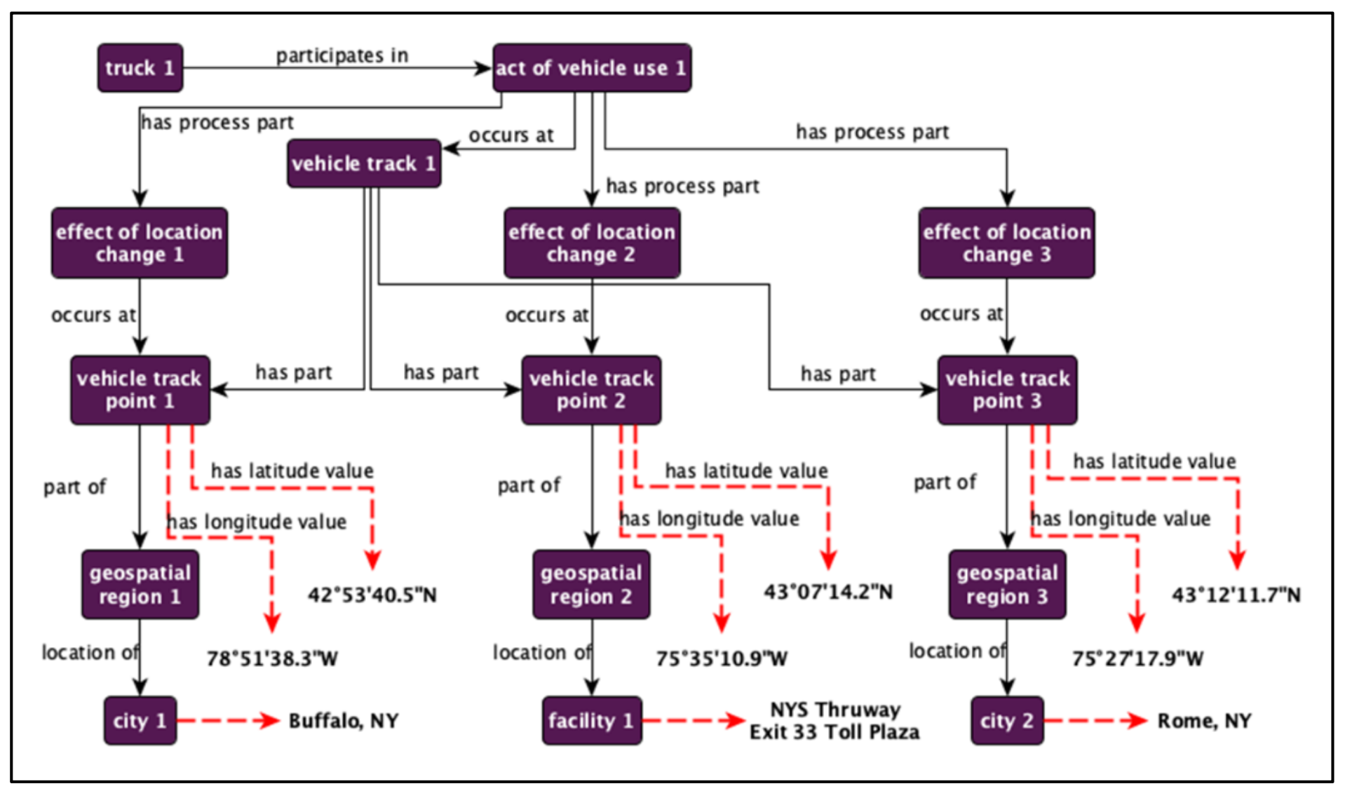
Suppose there is a need to represent the path taken by a ground vehicle over some geospatial region. The first figure below illustrates how such a use case would be modeled using CCO. The class material artifact - a material entity designed by some agent to realize some function - is the parent of vehicle, instances of which convey material entities from one location to another. Subclasses of vehicle are divided largely along the lines of aircraft, ground vehicle, spacecraft, and watercraft, all of which are designed to realize some conveyance function across some environment type. While any instance of truck is a ground vehicle, the latter class is further divided into rail transport vehicle – conveyance by railway - and ground motor vehicle – conveyance by motive power by an engine absent rails – where we find truck.

Tracing the path of an instance of truck involves identifying an act of vehicle use in which that truck participates. The act of vehicle use in turn has process part some location changes which occur at instances of vehicle track point. Generally, the relation occurs at holds between a process and a site, where a site is a three-dimensional immaterial entity whose boundaries coincide with some material entity, e.g. a hole in a straw, the trunk of a car. To say then that a process part of the act of vehicle use occurs at some vehicle track point is to imply the latter is a site. Each instance of vehicle track point is associated with latitude and longitude text values, and each is a part of distinct instances of geospatial region, which is a site at or near the surface of the Earth. Each geospatial region has a different location, such as Buffalo NY, or the New York State Thruway Exit 33 Toll Plaza, or Rome NY.
The temporal aspect of this scenario is illustrated in the next figure below. Suppose the act of vehicle use occurs at the Baghdad city of al-Kadhimya over the course of several months. One such occurrence happened during the month of May 2004. Any act of vehicle use will happen over a temporal interval, which is a continuous temporal region of one-dimension exhibiting no gaps, such as May 17th at 1:38PM EDT. This time of day is an interval during May 2004, which in this scenario is an interval during a multi- month temporal interval, perhaps consisting of June, July, and August as well. Note that, despite the label choice, multi-month temporal interval may, unlike the BFO class temporal interval, exhibit discontinuities and temporal gaps. The class exists to track repeated occurrences of a process across months. For more fine-grained representations, CCO additionally contains similarly contains multi-day temporal interval, multi- second temporal interval and so on.
These resources allow for the representation of partial descriptions of processes that refer to the same event using different granularities of time. For example, the statements “The truck is in Baghdad at 8:42PM on March 17th, 2004” and “A truck was in Baghdad on the evening of March 17th, 2004” may refer to the same event, and if so, would be linked using interval during relations.